
I would love to tell you that we just pack our bags, hop on our boat and set sail. Unfortunately, it’s not that easy. With us not having a cabin and being on a smaller boat, we have to plan it all out just right.
Some questions to consider before you start to plan your trip:
How long will we be gone?
This is always my first question before we start planning. Knowing how long we’ll be gone dictates many aspects of the trip.
How long are we comfortable boating each day?
When we first started these trips we would only boat anywhere from 50-75 miles a day. We’ve come to realize that we can handle more as long as we’re in areas where there is plenty to see (for us that could be a town/city or cool marshland). On this upcoming trip we will be traveling anywhere between 85 and 130 miles each day.
Where are we going?
This is an easy one for us because we have always said we wanted to conquer the entire intracoastal. Therefore, we trailer down to where we left off the year before. Last year we did Charleston, SC to St. Augustine, FL, so this year we will start back in the St. Augustine, FL area. Since we have 11 days to work with, averaging 110 miles a day, we decided to travel down to Key West.
Where are we stopping along the way?
This goes back to how long are you comfortable on the boat each day, speed, and side trips (stopping off before your overnight destination). We’re comfortable doing about five hours a day on the boat, and we go around 25-30mph. You have to also account for speed limits (this will be new to us this year; FL has these areas), no wake zones, and idle zones. We post on forums, such as Hull Truth, and look at phone apps, such as KnowWake and WakeWatch, to help determine our speeds. Once we determine how far we can go, we start to look at towns nearby to stay overnight.
Wait, how do we get back?
We backtrack to where we put in. This might not sound that great to some, but it works out nicely for us. We get to stay at towns that we missed on the way down, and we don’t have to have someone drive miles and miles to come pick us up.

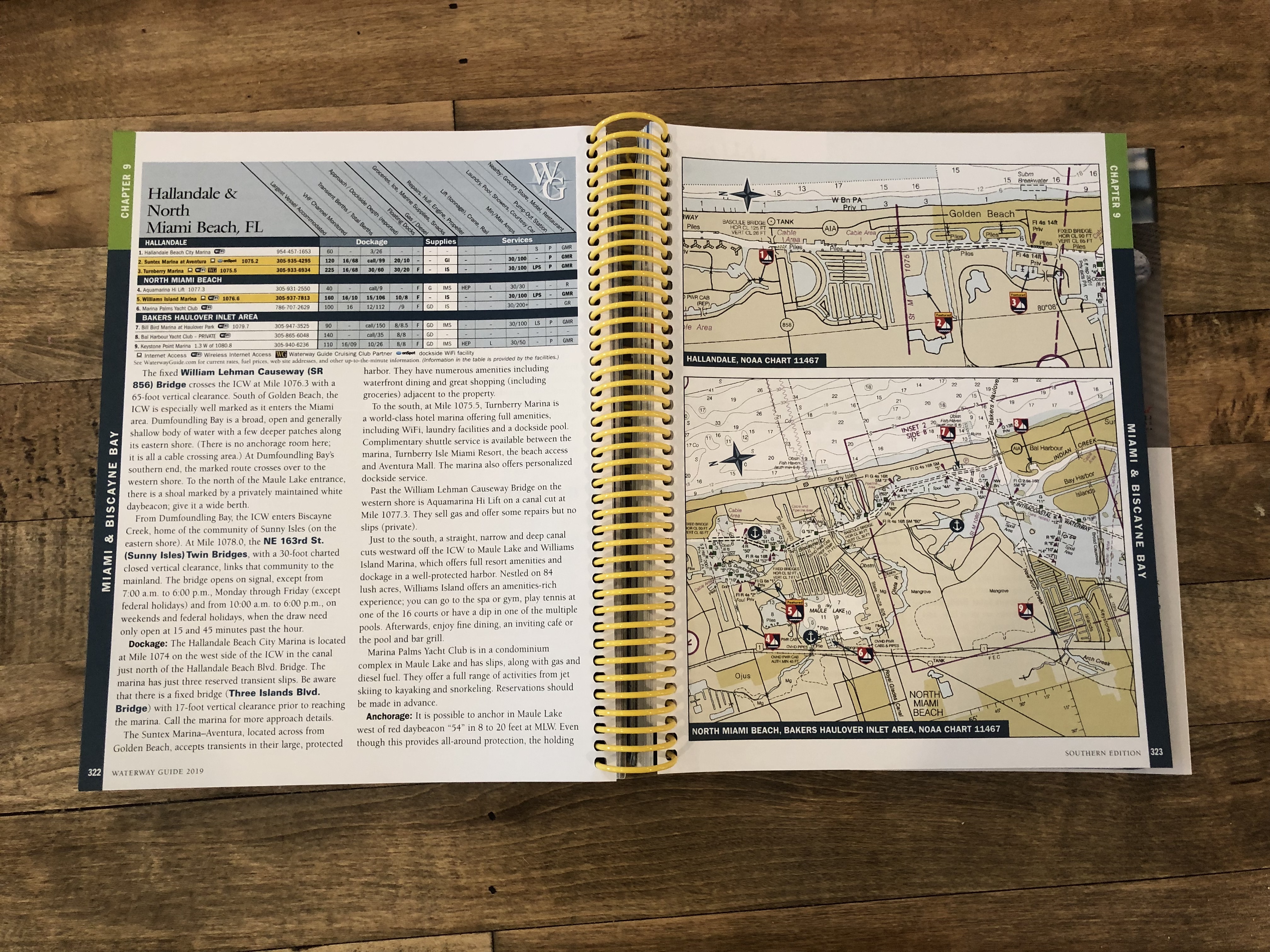

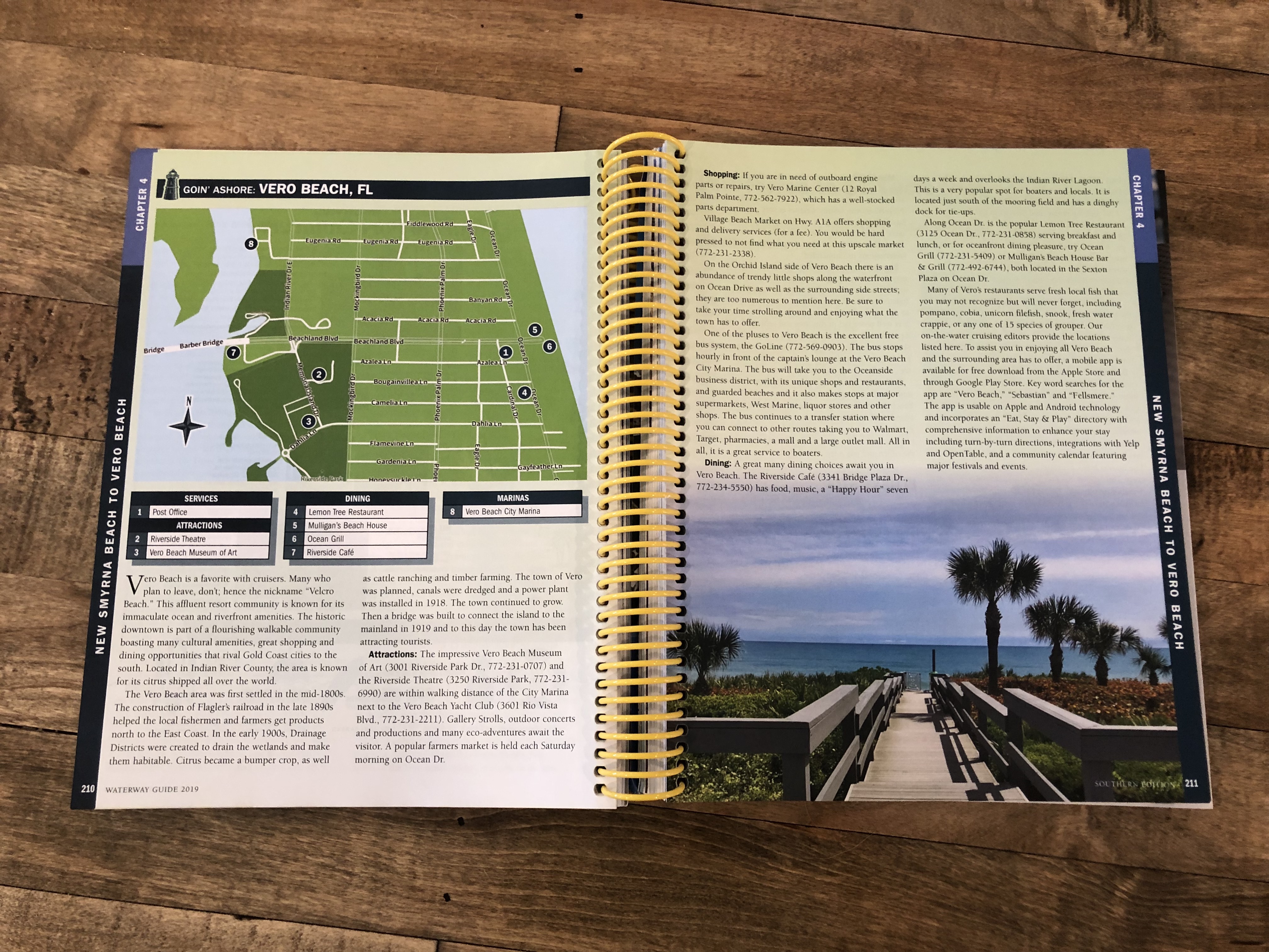
My favorite resource for this trip is the Waterway Guide. I have the books and also use the website. The guide shows you what towns are at different mile markers, which helps when you’re looking for towns a certain amount of miles away. Something we learned the hard way: these miles are nautical miles, not statute miles. Yes, this probably seems like common sense, but we totally didn’t think about that initially. We saw from point A to point B was 100 miles and we were traveling 25mph. We should be there in four hours, right? Nope. Over four and half hours. Might not sound like a big deal, but when you miscalculate longer mileage it can mess you up!
Another great resource is a towing membership. We decided to go with Tow Boat US. We used to have Sea Tow, and love them too, but this move was better for us. Tow Boat US has more of a presence on the waterway (they’re located every 30 miles down the ICW vs. Sea Tow every 60 miles), and they have a lot of discount partners. With our membership, we frequently get docking and fuel discounts.
This trip certainly takes a lot of planning, but it is so worth it! Stay tuned for other post including handling inclement weather, packing, trip necessities, more trip recaps and our plan for this year!
